What's essential to Los Angeles and the Southland? Why, driving of course.
And what's more essential to LA driving than our criss-crossing collection of freeways? Nothing, I'm guessing.
Here's some "neat" shots of the various locations and names of highways in an around LA county, and even a non-LA county destination. It's not Orange County, and good luck finding which one it could be.
First up on our non-exhaustive list of area highways is the Artesia Freeway, in the numerical nomenclature it's CA Hwy 91, Redondo Beach to Riverside. This is an actual freeway, bigger than US 101 in San Luis Obispo.
Here's a buy spot getting near downtown LA, where the arteries break apart like the branching aorta, 101 heading to downtown LA, I-5 heading to the mountains and north out of the city, and I-10 heading west to Santa Monica. The eastbound section of 10 is less than a mile away.
Here's where the 101 splits off just north of the city on it's way to Hollywood and Ventura, with the 110 becoming Interstate 110 heading south, through LA all the way to San Pedro, becoming the Harbor Freeway, and becoming CA Hwy 110 going up to Pasadena (that's probably more like "over to Pasadena" at this point).
CA Route 27 is also known as Topanga Canyon Road, and it dies/begins at the ocean into/from the PCH. I made sure I got the sign notifying the location: 4 miles to Santa Monica, 7 miles to Malibu.
Having seen CA Hwy 91, we see CA Hwy 90 here, the Marina del Rey Freeway. This seems to be a freeway link from the 405 through Culver City to Marina del Rey, a coastal community immediately south of Santa Monica. This is also the first picture of the famous CA Hwy 1, also known as the Pacific Coast Highway. Calling something "the Pacific Coast Highway" doesn't make as much sense when it's an urban street like Lincoln Blvd here, or Santa Rosa Rd, in my old college town. But it is what it is; weird things happen when it's an almost thousand mile long road.
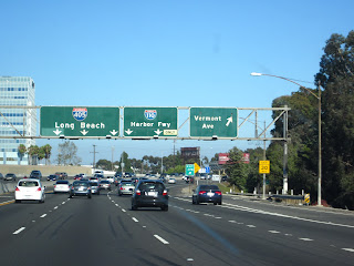
Briefly we see the 405, the San Diego Freeway on the way to Long Beach, as the spur 105 shoots off in two directions, one to Norwalk, and one to El Segundo. Norwalk is in the South-Central section of the city, while El Segundo is north of the Rancho Palos Verdes peninsula and even north of Torrance, but south of Redondo Beach (which itself of south of Santa Monica and Marina del Rey).
CA Rte 107 heads from Inglewood to Lawndale, to mostly forgotten communities in Central LA; neither is violent enough to become famous in the hip-hop arts, nor wealthy enough to influence politics.
Here we see the Harbor Freeway, I-110, again, as it crosses the 405 far south of where it originated, heading off to San Pedro.
And, getting back to where we started our journey, we meet up with the Long Beach Freeway, which heads south to Long Beach and north to Pasadena, while the 405 heads down to Orange County, where it meets up with I-5 and heads down to San Diego.
Lastly, here is the classic picture with the classic name, seen together. Oddly, this exit represents easily the ugliest stretch of this road. Before this crossing of the 710, the road signs in Long Beach all say "PCH", but it's really 18th street, a few miles from the ocean. On the west side of the 710, it stretches between refineries and industrial wastelands. At least the sign gives the right idea.


No comments:
Post a Comment